Walking
ACTIVITIES ON MOUNT PINNACLE
We invite you to visit the Mount Pinnacle Land Trust website: http://www.montpinacle.ca/
A registered charity dedicated to preserving nature in the Mount Pinnacle area in Frelighsburg, the Mount Pinnacle Land Trust currently protects 364 ha of land for perpetuity. It acquires land and negotiates conservation agreements with owners who wish to preserve natural environments for future generations. The Trust regularly provides educational activities to local school groups and the general public.
FRELIGHSBURG MUNICIPAL PARK
Enjoy amazing hikes on the trails of the Municipal Park (approximately 4 km). The parking is on your right on Richford Road, just outside the village.
Map of the Municipal Park trails
MORE HIKING TRAILS
The FR1 and FR2 trails are now open for walking, snowshoeing and cross-country skiing.
The trail map is available here, on the Vitalité Frelighsburg website and from the Tourist Information Office. You can also download the 2021 version: Sentiers FR1_FR2 (PDF Map).
FR1 TRAIL
15-kilometers long, this trail meanders over private lands, gravel roads and Chemin du Diable. Those who wish to hike a shorter distance can use one of the various shortcuts throughout the trail.
The first access point to this trail is on Chemin St-Armand, opposite the water treatment plant. First, the trail follows the bank of Rivière aux Brochets, then cuts through beautiful woodland to reach Chemin des Bouleaux. The hike continues on Chemin des Bouleaux, then Chemin Eccles Hill and east up Chemin du Diable to Chemin Verger modèle which leads back to the village. Let’s not forget that the condition and longevity of present and future trails are everyone’s responsibility.
The trail goes through private land, especially in its first section. Landowners signed a right of way agreement with Vitalité Frelighsburg. Therefore, it is crucial to stay on the trail and leave as few traces of your presence as possible. The trail is maintained and supervised by volunteers.
The trail is easy, with only a slight incline except in the western part of Chemin du Diable, and is open for hiking and cross-country skiing.
You can park your vehicles in the following areas:
-
- Rue de l’Église, at the designated locations (accesses 1 and 10)
- Chemin du Moulin à Scie (access 5)
- Chemin des Bouleaux (access 6 or 7)
- Chemin Eccles Hill or Chemin du Diable (access 8)
- Chemin Verger Modèle (access 9)
A huge thank you to the Dwyer, Levasseur and Lévesque families, to Pauline Alberta St-Pierre, and to the Chutes Hunter and Forêt de Freli campgrounds, who gave access to the trail!
FR2 TRAIL
This 12 km trail begins at the Municipal Park on Chemin Richford. You can view the trail map on the Municipality and Vitalité Frelighsburg websites and at the Tourist Information Office.
From the Municipal Park, this trail runs along Rivière aux Brochets and then goes up to a plateau where you have a great view to the southwest. The FR2 crosses Road 237 South and goes up in a pretty meadow along the river. The trail continues through the forest to Chemin Verger Modèle that leads back to the village.
You can park your vehicles in the following areas:
Municipal Park (12)
Shoulder of road 237 South (14)
Chemin Verger Modèle (15)
Heart of the Village (11)
The FR2 is not too challenging while offering interesting uneven terrains… This trail is possible thanks to the rights of way that the following owners have kindly granted Vitalité Frelighsburg: Gestion CJY Beaudoin inc, Clos McIntosh (Lucie Dagenais, Claude Bourdeau), 9206-5056 Quebec inc (Stacey Écuyer, Philippe Choinière), Bruce Johnston and Laure Waridel. Obeying the signage, remaining on the trail at all times and respecting the owner’s peacefulness is a must.
Happy hiking from the Vitalité Frelighsburg Trails Committee.
OTHER WALKING ROUTES
The walking routes we offer use rarely paved, low-traffic roads that give you a glimpse of our beautiful countryside.
We suggest parking your car at the beginning of the walking route.
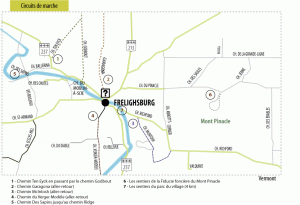
Chemin Ten Eyck via Chemin Godbout or back and forth on these individual roads.
Chemin Garagona (back and forth).
Chemin McIntosh (back and forth).
Chemin Verger Modèle, accessible from the centre of the village (back and forth).
Chemin des Sapins up to Chemin Ridge (back and forth)

Pour d’autres informations, nous vous invitons à visiter le site RandoQuébec : https://baliseqc.ca/hiver/

